EcoScope Platform

The EcoScope Platform will be a novel, modular, interdisciplinary e-tool integrating met-ocean, biogeochemical, environmental, biological, fisheries, and socio-economic datasets, covering all European Seas. The e-platform will provide both primary data and on-demand derived data services including forecasts, through a single public portal to various end-user groups, stakeholders, and the broader public. Through the EcoScope Platform, complex ecosystem functions and interrelations between abiotic-biotic-human components will be revealed and their spatio-temporal variability will be assessed and visualized. Data on oceanography, marine biogeochemistry, food webs, and ecosystem productivity within the framework of climate change and increased anthropogenic forcing will be aggregated.
Data will be collected and homogenized in terms of data types and formats according to international standards (where these exist, e.g., WMO, SeaDataNet, FishBase) in accordance with fair data principles (FAIR). Data stored temporarily in the modern CLS (participant 22 – CLS) data centre and eventually in a cloud server dedicated for this task but also work with Blue Cloud.
The EcoScope Platform will:
(a) integrate data from external data providers, like CMEMS (all data products, satellite, model outputs and on-site observations), EMODnet (bathymetry, biology, chemistry, human activities, geology, human activities data portals), GOOS (operational oceanographic data from on-line RT sensors like moorings, Argo-floats, gliders, benthic stations), SMHI (river outflows and nutrient fluxes), CORDEX (data from climate change scenarios), FAO, ICES and Sea Around Us (fishery data as catch time-series per species, biomass assessments and fleet statistics, all per ICES Ecoregions/GFCM subareas), Global Fishing Watch (fishing effort data), AquaMaps (species distributions), ESFRI (marine data from EMSOERIC, Euro-Argo ERIC, LifeWatch ERIC and Daniubius RI), benthic biodiversity (Marine IBA e-atlas), marine mammals (ACCOBAMS) and more, and
(b) assimilate data, model results and indicators produced within the framework of the EcoScope project, in relation to environmental, human (WP4) and economic (WP7) drivers, indicators and assessments (WP5) and ecological models (WP6). For example, the EcoScope Platform will integrate the expected impacts of climate change scenarios on sea surface temperature (SST), sea surface salinity (SSS), primary production, ice cover, etc. as produced by WP4 (Task 4.1); the biodiversity indicators and stock assessments from WP5 (Tasks 5.1, 5.2); the ecosystem modelling data and deep uncertainty simulation results from WP6 (Tasks 6.1, 6.2) and economic indicator data from WP7 (Task 7.2).
The EcoScope Platform will follow the architectural design and principles developed in the ODYSSEA H2020 Project (Mediterranean Sea platform) and therefore it will be composed of the following modules:
Storage component storing and organizing data into topics like meteorology, bathymetry, hydrology, hydrography, geology, physics, chemistry, biology, biodiversity, human impacts, etc. These data will be further classified into:
(a) Static/archived datasets, collected once or at long irregular intervals, such as bathymetry, geology, biodiversity, habitats, etc.
(b) Dynamic historical data, in mean-monthly time-series form. Assessed forecasts, such as climate change data per scenario. Operational, short-term forecasts will not be included in the databases of EcoScope, as these will not directly affect fisheries and socio-economic model outputs or indicators.
Catalogue component, as a pre-processing step prior to data injection into the system. This component ensures data harmonisation and standardisation, linking data to external platforms through an OGC Catalogue Service of the Web interface and metadata organisation, following the standards ISO/TC2112, ISO19115 and ISO 19139 for georeferenced metadata.
User Management component, allowing the registration and authentication of end-users to the EcoScope Platform, according to the provisions of GDPR on users’ personal data protection and privacy requirements (95/46/EC).
Analysis and Reporting Component, supporting the data processing and manipulation (e.g., interpolation, filtering, fitting, signal processing, aggregation), statistical analysis toolbox (descriptive statistics, distributions, etc.) and reports to display in the web portal (e.g. plotting and mapping services).
Dissemination Component, allowing the user to visualise maps and time-series and extract them in various forms.
Update: The EcoScope Platform is now available!
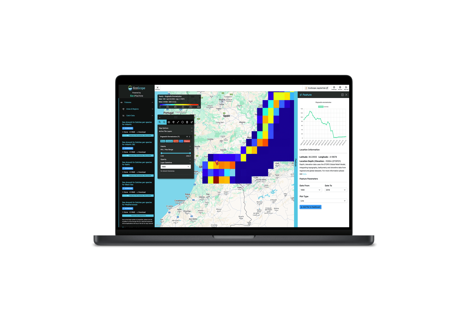
Try The EcoScope Platform
The EcoScope Platform brings together marine data such as weather, ocean chemistry, biology, fishing effort and catch data from across European seas. It offers raw data and climate scenarios that explore the potential changes in distribution to critical species under RCP scenarios. Try it today and explore how marine ecosystems and human activity interact over time.