EcoScope research uses AI to fill in marine environmental parameters in ecological models
A new AI method allows ecological models to fill in missing marine environmental parameters and thereby more quickly and efficiently produce results, EU-funded EcoScope project researcher Gianpaolo Coro, of the Italian National Research Council’s Institute of Information Science and Technologies (CNR - ISTI) InfraScience Infrastructure for Science Lab, explained in a recently published article.
The AI-based automatic spatial interpolation method “generates a homogenous parameter field (as a raster file) from scattered marine environmental parameter observations without requiring external parameterisation from the user,” Coro noted.
“The inspiration for this work started while I was working on the gap-filling method used in (EcoScope project task) T4.4 and the ecological niche models (EcoScope project task) T4.3”, Coro recounted. Coro added that the gap-filling method used by EcoScope is also currently “the backbone” of the processes used by the Italian National Research Council’s Institute for Marine Biological Resources and Biotechnology (IRBIM) to produce data for the General Fisheries Commission for the Mediterranean (GFCM) and EU Scientific Technical and Economic Committee for Fisheries (STECF).
Coro’s research and information on using the method was published in the scientific journal Environmental Modelling and Software under the title “An Open Science oriented Bayesian interpolation model for marine parameter observations”. Links are provided to access the service at no cost.
Filling gaps when building ecosystem models is common practice, Coro explained, yet problems particular to oceanological phenomena complicate the usual methods and require special attention.
“Ecological and ecosystem modellers frequently need to interpolate spatiotemporal observations of geophysical and environmental parameters over an analysed area. However, particularly in marine science, modellers with low expertise in oceanography and hydrodynamics can hardly use interpolation methods optimally,” he said.
In his research, Coro proposes using the Bayesian Interpolation Model with Advection-diffusion Constraint (BIMAC), an “Open Science oriented, open-source, scalable and efficient workflow for 2D marine environmental parameters”. Such a method combines a fast and efficient interpolation method with a Bayesian hierarchical model that embeds the stationary advection-diffusion equation as its constraint, allowing it to be run entirely automatically, without the need for expert parameterisation, Coro said. In this way, the method proposed “fills the usability gap” separating interpolation software providers from the end-user communities implementing the software, he added.
“The motivation that brought us to this study is that large communities of users of high-quality data-gridding algorithms have requirements that still need to be met by modern implementations,” Coro said.
“We demonstrate that our workflow produces comparable results to a state-of-the-art model (frequently used in oceanography) in interpolating four environmental parameters at the global scale”, he emphasised.
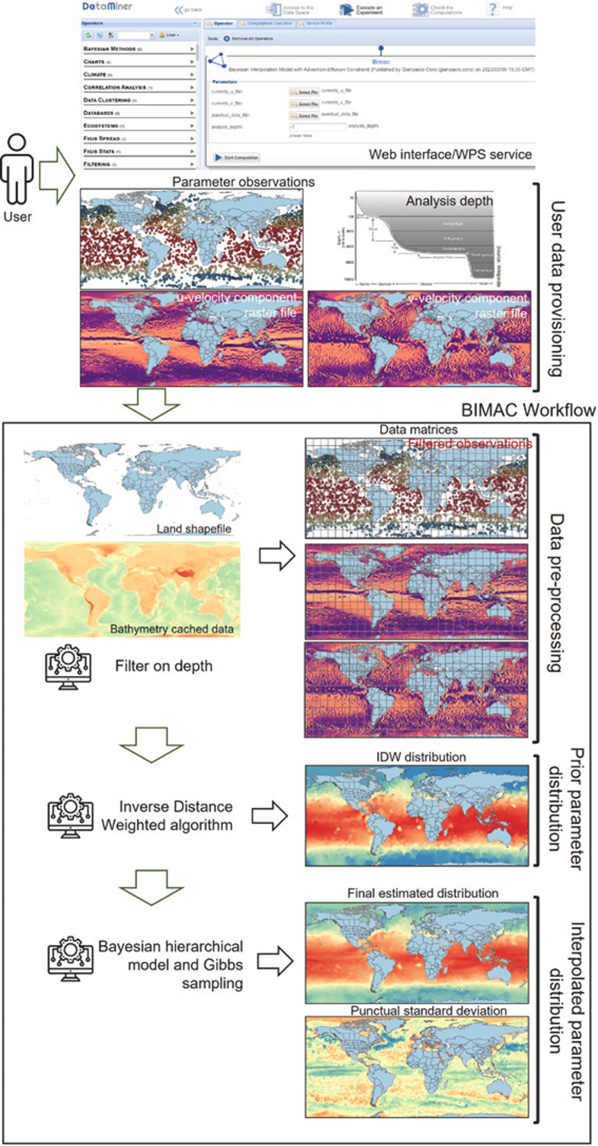
BIMAC’s “main novelty”, Coro pointed out, is that it meets ecological and ecosystem modellers’ crucial requirements, such as (1) the possibility to automatically infer all workflow input parameters without requiring expert knowledge in oceanography, (2) support of Open Science features of repeatability, reproducibility, and re-usability of the process, and (3) the availability of a free-to-use, standardised and easily integrable cloud-computing Web service supporting collaborative experimentation.
Coro’s AI Open Science modelling method described is available on a cloud computing platform, with a Web Processing Service compliant interface, which he noted supports collaboration, repeatability, reproducibility and provenance tracking.